Kivu Catchment (CKIV)
The Kivu catchment consists of the numerous lateral small catchments that drain the Western side of the water divide between the Nile and the Congo basin. The water divide runs in a north south direction in the West of Rwanda. Thus, each one of these small catchments classifies as an upstream catchment that drains directly into Lake Kivu. Further inflow to Lake Kivu comes from the DRC making the Lake Kivu catchment transboundary between Rwanda and the DRC. The Lake Kivu waters ultimately flow into the Rusizi River.
The downstream limit of the catchment is positioned at the outflow of Lake Kivu in the Rusizi River which is largely defined by the operation of the Rusizi 1 hydropower station. This power station is owned and operated by the DRC.
With a clearly defined transboundary catchment area, no upstream inflow area and an outflow location, the Lake Kivu catchment is properly demarcated. A subdivision of the catchment or a downstream extension would compromise the monitoring of the catchment outflow and thus one of the prerequisites for proper water management.
The surface areas of the different parts of the catchment are as follows:
- Land area of the catchment within Rwanda : 2,425 km² (of which 245 km² is reserved area in Nyungwe forest and the volcano park)
- Land area of the catchment in DRC (including Ijwi island) : 2,203 km²
- Surface area of Lake Kivu : 2,695 km²
- Totall area of the catchment : 7,323 km²
The catchment area is essentially covered by the following six districts (Rubavu, Nyabihu, Rutsiro, Karongi, Nyamasheke and Rusizi). Some minute areas of the catchment are located in the districts of Musanze, Ngororero and Nyamagabe.
A further subdivision of the elongated level 1 catchment of 2,425 km² has been suggested as follows for the creation of three level 2 sub-catchments :
- The Sebeya River in the north in combination with the lava region where surface flow is intricately combined with groundwater. The Sebeya River has a major problem with high sediment load aggravating to extreme levels during floods. This problem has evidently increased over the last decennium or so. This justifies a (sub-) catchment wide approach to solve or redress the situation. This subcatchment is essentially located in the domain of the districts of Rubavu, Nyabihu and Rutsiro.
- The series of minor catchments from Rubona (near Gisenyi) to Rwamatamu (south of Kibuye) are all quite similar in nature in the sense of erosion control and extreme population pressure leading to inappropriate agricultural practices from the highlands down to the shores of Lake Kivu. This subcatchment is essentially located in the domain of the districts of Rutsiro, Karongi and Nyamasheke.
- The series of minor catchments on the southern shores of Lake Kivu from Kilimbi to Cyangugu. These catchments are different in the sense that they originate in the protected forest area of the Nyungwe forest for which strict protection measures are applied. This subcatchment is essentially located in the domain of the districts of Nyamasheke and Rusizi.
The principal water resources in the catchment are as follows :
- the average annual rainfall is slightly above 1,200 mm/annum which equates to some 3 000 hm³/annum from the total land surface area of 2,425 km².
- the combined average annual surface flow generated from the numerous small catchments in Rwanda stands at 28 m³/s or some 900 hm³/annum
- the groundwater annual recharge / safe yield is about 600 hm³/annum with a total storage of 2,400 hm³/annum which gives a mean residence time of about 4 to 5 years.
- the Kivu Lake collects the surface runoff from the entire catchment located both in Rwanda and DRC and constitutes an important surface water storage reservoir but generates substantial loss of water resources from evaporation.
Land characteristics in the catchment are summarily presented as follows :
- the lithology of the catchment is defined by volcanic material (basalt and granite rock) in the north and south, quartz rich schists in fault zones in the center and south and granite (different degrees of alteration) and pegmatite found in the intermediate areas. Notwithstanding generally deep weathering, these aquifers have a low storage capacity and conductivity. Unless located on a fault zone, boreholes will have low yields.
- the soil classes are predominantly the 'nitosol - acricol -alisol - lixisol' class found throughout the catchment area, as are pockets of ferralsol and cambisol. This is completed with andosols in the north. Infiltration rates of these soils are generally high. This is obviously not the case for the clay and mineral sols on flat topography encountered in the north and center of the catchment.
- the land cover of the catchment dominated by rainfed agriculture and forest plantation on the hill sides with limited irrigated or agricultural wetland in valley bottoms. Most of the former Gishwati forest area has been converted to natural open land used for grazing and dairy production. Reserved natural forest areas are found in the north (Park des Volcans), the Nyungwe forest and the remnants of the Gishwati forest. Built-up areas are rather limited in size and mostly restricted to the urban centers of Rubavu, Karongi and Rusizi..
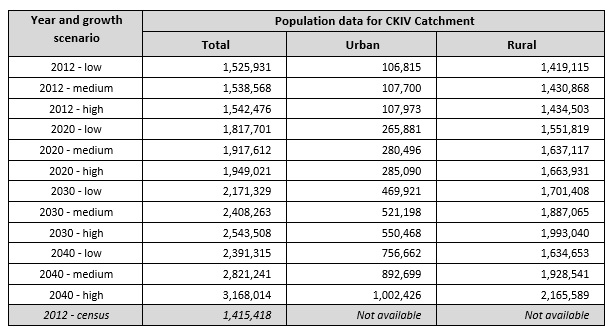
As of 2012, the total population in the catchment was assessed (2012 population census) at 1,415 million, with highest densities in and around the urban centers of Rubavu, Rusizi and Karongi. Catchment wide population data are given in the table below. The provisional 2012 census data per sector have been converted to population per catchment. The 2012 census result for the CKIV catchment stands at 1,415,418 population which is 7.24 % below the low growth scenario projection. Over the period 2002 - 2012 this equates to an annual difference of 7.0 ‰ (overestimation of the projection data).
As regards the development of land resources, and as already indicated above, the bulk of the land is used for rainfed agriculture, forest plantation and natural open land for dairy production. Bench - and radical terraces are implemented throughout the catchment but the surface area thus protected from erosion, remains limited. Cheaper erosion protection works like trenches, contour plantations, etc. are widespread. Borders of lakes and water courses are protected by law from exploitation for agricultural use. Urban areas are limited in size and not very crowded. Agricultural wetlands are few.