Muvumba Catchment (NMUV)
The Muvumba catchment consists from upstream to downstream of the relatively small catchment of the Mulindi River that is located in the mountainous and high rainfall central northern part of the country. The Mulindi River flows into Uganda onto a flat wetland zone near Kabale from where a complex flow pattern originates that ultimately joins the Muvumba River before it eventually flow back into Rwanda. Within Rwanda a number of relatively small tributaries join the Muvumba River which flows in a north easterly direction to follow the border between Rwanda and Uganda before finally joining the Akagera River in the North East where the borders of Uganda, Rwanda and Tanzania meet.
A small catchment (Nyabyondo River) within Rwanda which is not part of the Akagera basin but ultimately drains into Lake Edward, has been 'administratively' attached to this catchment as it is far too small to merit an exclusive management structure.
In conclusion, the Muvumba catchment is a complicated management unit because it is transboundary both for its upstream - and downstream part.
The surface areas of the different parts of the catchment are as follows:
- Land area of the hydrological catchment area within Rwanda: 1,568 km²
- Land area of the hydrological catchment area in Uganda: 2,146 km²
- Surface area of the KIR catchment draining to Lake Edward: 24 km²
- Total administrative area of the NMUV catchment: 1,592 km²
The administrative catchment area is essentially administered by the districts of Gicumbi and Nyagatare. A much smaller yet significant part of the catchment falls under the authority of the Gatsibo district. The attached catchment of Nyabyondo River along with some minute diversions from the natural catchment boundary are located in Burera district. A further minute diversion of the district boundary from the natural hydrological boundary involves the Rulindo district.
A subdivision of the level 1 catchment of 1,568 km² has been suggested as follows for the creation of two level 2 sub-catchments :
- The Mulindi River including the mini basin near Kivuye (Nyabyondo River) comprising the western part of the catchment which drains high rainfall highland area (measuring 260 km²) and runs over some 50 km of watercourse through Uganda before it returns to Rwanda.
- The Muvumba River and its tributaries from the entry point on the Ugandan border which drains into the Kagitumba River which follows the border between Rwanda and Uganda to finally join the Akagera. This larger part of the catchment is mainly sloping undulating land with potential for livestock production and high demand for a number of competing uses especially irrigation and livestock production with complex trans boundary management requirements (area of 1,308 km² in Rwanda).
The principal water resources in the catchment are as follows :
- the average annual rainfall is rated at 995 mm/annum which equates to some 1,560 hm³/annum from the total land surface area of 1,568 km².
- the combined average annual surface flow generated from the numerous small catchments in Rwanda stands at 6.9 m³/s or some 193 hm³/annum.
- the groundwater annual recharge / safe yield is about 111 hm³/annum with a total storage of 1,565 hm³ which gives a mean residence time of about 14 years.
- there is no significant surface water storage within the catchment area within Rwanda or Uganda.
Land characteristics in the catchment are summarily presented as follows:
- the lithology of the catchment is, for its western part draining into Uganda through the Mulindi River, characterized by alternating schist and quartzite layers with average groundwater potential mainly for local supply. The Eastern part is dominated by granite as the dominant basement aquifer which, notwithstanding generally deep weathering, results in low storage capacity and conductivity. Unless located on a fault zone, boreholes will have low yields.
- the soil classes are distinct between the western Mulindi River part where the 'nitosol - acricol -alisol - lixisol' class dominates with pockets of ferralsol and cambisol and the eastern Muvumba River part where ferralsols are abundantly found. Near the boundary between the two level 2 sub-catchments the class of 'mineral soils conditioned by flat topography' is available while the remainder of the Muvumba River catchment presents further pockets of mainly cambisols. The Mulindi River valley tends to the histosol class while the soils of the Muvumba river valley belong to the 'clay soil with low infiltration rate' class. Except for this last class and the 'mineral soils conditioned by flat topography', infiltration rates throughout the catchment are generally high.
- the land cover of the catchment largely dominated by rainfed agriculture with natural open land and limited forest plantation on the hill sides completed with limited irrigated or agricultural wetland in valley bottoms of the Mulindi and Muvumba Rivers. Built-up area is limited in size and mostly restricted to the, not very dense, urban centers of Nyagatare and Gicumbi as well as dispersed centers throughout Nyagatare district area.
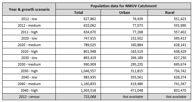
As of 2012, the total population in the catchment was assessed (2012 population census) at 725 thousand with highest density in and around the urban center of Nyagatare and throughout the Gicumbi district. Catchment wide population data are given in the table below. The provisional 2012 census data per sector have been converted to population per catchment. The 2012 census result for the NMUV catchment stands at 725,068 population which is 14.24 % above the high growth scenario projection. Over the period 2002 - 2012 this equates to an annual difference of 1.34% (underestimation of the projection data).
As regards the development of land resources, and as already indicated above, the bulk of the land is used for rainfed agriculture, forest plantation and natural open land for dairy production. Bench - and radical terraces are implemented throughout the catchment but the surface area thus protected from erosion, remains limited. Cheaper erosion protection works like trenches, contour plantations, etc. are widespread. Borders of water courses are protected by law from exploitation for agricultural use over a width of 10 m but this is not everywhere respected. Urban areas are limited in size and not very densely populated. Agricultural wetlands are limited to the Mulindi and Muvumba river valleys yet they are crucial production zones.