Upper Nyabarongo (NNYU)
The Upper Nyabarongo catchment originates on the eastern flanks of the majestic hills of the Nyungwe high altitude rainforest. This area is fully protected and essentially void of human occupants. The western side of the rather elongated catchment follows the water divide between the Nile and the Congo basins over its entire length. The most southern tip of the catchment first flows due east to make a circular move to a northern direction. The general drainage pattern is from south to north with a dense dendritic drainage pattern prevailing in most areas. The catchment is an upstream catchment and entirely located within Rwanda. Depending on the definition that is used (longest distance), the source of the River Nile may be found in this catchment.
The downstream limit of the catchment is positioned at the confluence of the Nyabarongo River with the Mukungwa River. With a clearly defined catchment area, no upstream inflow area and an outflow location, the upper Nyabarongo catchment is properly demarcated. Any change to this configuration would compromise the monitoring of the catchment outflow and thus one of the prerequisites for proper water management.
The surface areas of the different parts of the catchment are as follows:
- Total area of the NNYU catchment : 3,348 km² (entirely located within Rwanda)
- Area covered by natural forest : 233 km² (7% of total area)
The catchment area reaches out over the following eight districts : Ngororero, Rutsiro, Muhanga, Karongi, Nyamagabe, Ruhango, Nyanza, and Huye. Some minute areas of the catchment are located in the districts of Nyamasheke and Nyaruguru.
A further subdivision of the level 1 catchment area of 3,348 km² has been suggested as follows for the creation of three level 2 sub-catchments :
- Mbirurume subcatchment (NNYU_1) with the Mbirurume River draining an upland catchment with steep longitudinal and lateral slopes which is partly covered with the Nyungwe forest area (area of 511 km² in Rwanda).
- Rukarara Mwogo subcatchment (NYU_2) comprising the Mwogo river in combination with its tributary the Rukarara River. This subcatchment is quite similar in nature to the Mbirurume subcatchment (area of 1,284 km² in Rwanda).
- Nyabarongo (NNYU_3) subcatchment. The remainder of the catchment is drained by the upper Nyabarongo which originates at the confluence of the Mbirurume and Mwogo rivers. This sub catchment is again similar in nature to the preceding ones; a mountain stream cutting through the hills with a gradually increasing flow (area of 1,553 km² in Rwanda).
The principal water resources in the catchment are as follows :
- the average annual rainfall is 1,365 mm/annum which equates to some 4,570 hm³/annum from the total land surface area of 3,348 km².
- the combined average annual surface flow generated from the numerous small catchments stands at 41 m³/s or some 1,290 hm³/annum.
- the groundwater annual recharge / safe yield is about 978 hm³/annum. With a total groundwater storage estimated at about 25,000 hm³/annum this leads to a mean residence time of groundwater of some 25 years.
Land characteristics in the catchment are summarily presented as follows:
- the lithology of the catchment is made of granite and pegmatite in its southern region and a small area in the north-west part. The central part is dominated by shale with intrusions of (quartz rich) schists and rather thin bands of quartzite. Due to a deep weathering, these aquifers have a reasonable storage capacity; apart from the quartzite deposits, conductivity is generally low. The lithology is completed with alluvial deposits and volcanic material at some rare locations. Apart from occasional fault zones and the alluvial deposits, boreholes will have low yields.
- the majority of the soil classes found in the catchment belong to the 'nitosol - acricol -alisol - lixisol' class followed by ferralsol and cambisol classes. These soil classes present high infiltration rates. The picture is completed with mineral soils conditioned by flat topography with some dominance in the south western and central parts of the catchment and small areas of clay soils with low infiltration rates.
- the land cover of the catchment is mainly rainfed agriculture. The eastern and southern parts have a relatively high number of irrigated/agricultural wetland in rather narrow valley bottoms. The catchment further presents natural forest (Nyungwe forest) in its south-western part and a very small portion in the north-west (Gishwati forest). Other land uses encountered are: natural open land, forest plantations and built-up area in urban centers (Nyamagabe, Nyanza, Ruhango and Muhanga). These last categories cover a small surface area in comparison with the first ones.
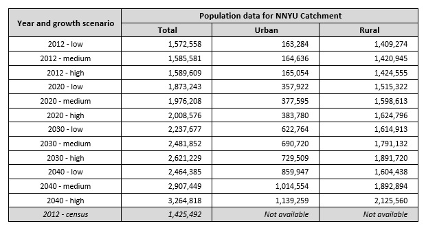
As of 2012, the total population in the catchment was assessed (2012 population census) at 1,425 million dispersed throughout the catchment with highest densities in and around the urban centers of Muhanga and Nyamagabe followed by Ruhango and Nyanza. Population density is low in the Nyungwe forest area and the Mugano sector of Nyamagabe district. Catchment wide population data are given in the table below. The provisional 2012 census data per sector have been converted to population per catchment. The 2012 census result for the NNYU catchment stands at 1.425.492 population which is 10,32 % below the low growth scenario projection. Over the period 2002 - 2012 this equates to an annual difference of just under 1% (0,987%) (overestimation of the projection data).
As regards the development of land resources, and as already indicated above, the bulk of the land is used for rainfed agriculture and irrigated agriculture in wetlands in its eastern and southern region. Bench - and radical terraces are implemented throughout the catchment but the surface area thus protected from erosion remains limited. Cheaper erosion protection works like trenches, contour plantations, etc. are widespread. Borders of water courses are protected by law from exploitation for agricultural use over a width of 10 m. Urban areas are limited in size and not very crowded.