Rusizi Catchment (CRUS)
The Rusizi catchment is part of the Congo River basin and drains the area along the Rusizi river where this river forms the border between Rwanda and the DRC until it reaches Burundi at the confluence of the Ruhwa and Rusizi rivers. The Rusizi River is the outflow of the Kivu Lake and conveys its waters to Tanganyika Lake
Within Rwanda, the catchment area can be divided in four distinct domains; i) a narrow stretch of land directly along the Rusizi river that drains into this river through a number of short water courses, ii) the catchment area of the Rubyiro river which is an upstream catchment entirely located within Rwanda which drains into the Rusizi about 1 to 2 km upstream of the Ruhwa river, iii) the catchment area of the Ruhwa river which originates in the Nyungwe Forest area and which forms the border between Rwanda and Burundi until it falls into the Rusizi, and iv) the southernmost tip of the Nyungwe forest in Nyaruguru district which is drained by the Kaburantwa River which flows south to Burundi where it finally joins the Rusizi River further downstream.
The downstream limit of the catchment is the confluence of the Ruhwa and Rusizi rivers at the place where Rwanda, Burundi and the DRC meet.
With a clearly defined upstream inflow area (CKIV), a clearly defined transboundary catchment area and an outflow area that drains more than 90% of the domain, the Rusizi catchment area is satisfactorily demarcated. An upstream extension would compromise the monitoring of the catchment and a downstream extension on Rwandan territory is not possible.
The surface areas of the different parts of the catchment are as follows :
- Land area of the catchment within Rwanda : 1,005 km² (of which 503 km² is reserved area in Nyungwe forest)
- Land area of the catchment in RDC : 368 km² (across the Rusizi River)
- Land area of the catchment in Burundi : 638 km² (across Ruhwa River)
- Rubyiro catchment area within Rwanda : 420 km²
- Ruhwa River within Rwanda : 585 km²
- Total area of the CRUS catchment : 2,011 km²
The upstream inflow area into the Rusizi River from the CKIV catchment totals 7,323 km² of which 2.425 km² is land area within Rwandan territory.
The catchment area is essentially covered by one district (Rusizi). Some small areas of the catchment are located in the district of Nyaruguru and Nyamasheke.
A further subdivision of the semi circular level 1 catchment of 1,005 km² has been suggested as follows for the creation of two level 2 sub-catchments :
- the CRUS_1 level 2 catchment is the Rubyiro River which is extensively used for rice production;
- the CRUS_2 level 2 catchment is the Ruhwa River which originates in the Nyungwe Forest and constitutes a natural border between Rwanda and Burundi. The upper reaches of the Ruhwa River are subjected to artisanal gold mining activities with significant sediment pollution as a consequence. The southern tip of the Nyungwe forest is integrated in this subcatchment as it doesn't justify a separate sub catchment.
- the Rusizi River on the border between Rwanda and the DRC and its direct inflow area completes the CRUS_1 level 2 catchment. The Rusizi River itself is exploited for hydropower with untapped additional hydropower potential currently being investigated.
- Lake Kivu catchment area is located upstream of the Rusizi River catchment hence it defines the flow regime and water quality of the Rusizi River to a large extent.
- the outflow of the catchment is at the confluence of the Rusizi and Ruhwa Rivers where the three nations Rwanda, DRC and Burundi share their border.
The principal water resources in the catchment are as follows:
- the average annual rainfall is slightly below 1,300 mm/annum (1,295 mm) which equates to some 1,300 hm³/annum from the total land surface area of 1,005 km².
- the combined average annual surface flow generated from the catchment area within Rwanda stands at 4.5 m³/s or some 142 hm³/annum
- the groundwater annual recharge / safe yield is about 269 hm³/annum. With a total storage of 5,000 hm³/annum the mean residence time of groundwater is about 19 years.
- the Rusizi River collects the surface runoff from most of the catchment located in Rwanda, Burundi and DRC
- the Rubyiro River collects the surface water within the first level 2 sub-catchment and drains into the Rusizi River.
- the Ruhwa River collects the surface water from the second sub-catchment and drains into the Rusizi River.
Land characteristics in the catchment are summarily presented as follows:
- the lithology of the catchment is defined by volcanic material (basalt and granite rock) in the west, quartz rich schists in fault zones in the center and the north-east; a quartz deposit in a large band in the center, shale in the center and west, alluvial material in valley bottom in the western part of the catchment and finally granite (different degrees of alteration) and pegmatite are found in the east especially the Nyungwe area. The quartzite aquifer provides more favorable recharge and storage conditions, while the granite basement aquifer has lower recharge, faster recession and less storage.
- the soil classes are predominantly the cambisol class found throughout the catchment area, as are pockets of ferralsol and 'nitosol - acricol -alisol - lixisol'. Infiltration rates of these soils are generally high. This is obviously not the case for the clay and mineral sols on flat topography encountered in the west in the Bugarama valley. Histosols are found in some pockets in high altitude valleys in the west (Gishoma).
- the land cover of the catchment is partly dominated by the natural forest (Nyungwe forest reserve). Rainfed agriculture dominates outside the forest reserve with forest plantations in the former Nyungwe domain. There is a significant part of the catchment as irrigated or agricultural wetland in valley bottoms. Small pockets of the catchment mainly in the west have been converted to natural open land used for grazing and dairy production. Built-up areas are rather limited in size and mostly located in the Bugarama valley.
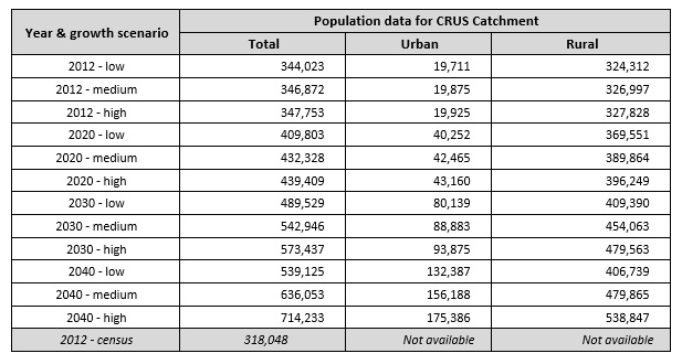
As of 2012, the total population in the catchment was assessed (2012 population census) at 318,000 dispersed throughout the catchment but outside of the Nyungwe forest reserve. Highest densities are found in and around the Bugarama valley. Catchment wide population data are given in the table below. The provisional 2012 census data per sector have been converted to population per catchment. The 2012 census result for the CRUS catchment stands at 318,048 population which is 7.56 % below the low growth scenario projection. Over the period 2002 - 2012 this equates to an annual difference of 7.3 ‰ (overestimation of the projection data).
As regards the development of land resources (outside the Nyungwe forest area), and as already indicated above, the bulk of the land is used for rainfed agriculture, forest plantation and natural open land for dairy production. The Bugarama valley is extensively used for irrigated rice production. Bench - and radical terraces are implemented throughout the catchment but the surface area thus protected from erosion, remains limited. Cheaper erosion protection works like trenches, contour plantations, etc. are widespread. Borders of water courses are protected by law from exploitation for agricultural use. Urban areas are limited in size and not very crowded.