Mukungwa Catchment (NMUK)
The Mukungwa catchment comprises a large zone with tuff and lava deposits sloping downward from a series of five towering volcanoes characterized by rather thinly distributed, partly ephemeral and discontinuous surface channels interacting with very complex and intricate groundwater flows in the north-west. The East of the catchment features steep hills that drain onto a spectacular cascading system of high altitude wetland (Rugezi) and lakes (Burera and Ruhondo) from which the Mukungwa River emerges in the centre of the catchment. This river drains the remaining upland valleys and slopes in the central and southwestern part of the catchment in a mostly southern direction towards its confluence with the Nyabarongo River.
Except for some insignificant exceptions, the Mukungwa catchment watershed follows the frontier between Rwanda and DRC and between Rwanda and Uganda and the Mukungwa catchment classifies as a national and upstream catchment where all incoming waters originate from rainfall.
The downstream limit of the catchment is positioned at the confluence with the outflow of the Upper Nyabarongo catchment where both waters drain onto the Lower Nyabarongo catchment.
With a clearly defined catchment area, no upstream inflow area and an outflow location, the Mukungwa River catchment is properly demarcated. A subdivision of the catchment or a downstream extension would compromise the monitoring of the catchment outflow and thus one of the prerequisites for effective water management.
The surface areas of the different parts of the catchment are as follows :
- Catchment management area within Rwanda : 1,902 km² (of which 119 km² is reserved area in the volcano park)
- Land area of the catchment in Uganda (Chahafi and Kayumba Lakes) : 62 km²
- Surface area of the catchment that drains to Uganda : 15.2 km²
- Total area of the NMUK catchment : 1,949 km²
The catchment area is essentially covered by the following five districts (Burera, Musanze, Gakenke, Nyabihu, and Ngororero). Some minute areas of the catchment are located in the district of Gicumbi
A further subdivision of the level 1 catchment of 1,887 km² has been suggested as follows for the creation of two level 2 sub-catchments :
- The Rugezi Burera Ruhondo cascade of water bodies in the East comprising the Rugezi wetlands with the Burera and Ruhondo Lakes as a single management unit where agricultural, ecological/hydrological and hydropower interests need to be reconciled. This is the NMUK_1 subdivision most of which is administered by the Burera District.
- The remainder of the catchment (NMUK_2) features complex surface and groundwater interactions in the lava region and more regular interactions in the remainder of the catchment, supporting predominantly subsistence agriculture with an even for Rwandan standards, high population density. The upper reaches of this catchment is a reserved area (Volcano Park) which houses the world famous mountain gorillas and supports a successful high end tourism industry. The lava zone is predominantly located in the Musanze district, while the remaining area with mostly deeply wheathered soils from granite and schists is administered by the districts of Nyabihu and Gakenke.
The principal water resources in the catchment are as follows:
- the average annual rainfall is slightly above 1,315 mm/annum which equates to some 2,563 hm³/annum from the total land surface area of 1,949 km².
- the average annual surface flow generated from this catchment stands at 28.7 m³/s or some 900 hm³/annum (905 hm³/annum to be exact).
- the groundwater annual recharge / safe yield is about 630 hm³/annum with a total storage of 4,870 hm³ which gives a mean residence time of about 8 years.
- the Burera and Ruhondo lakes collect the surface runoff from about a third of the catchment area (682 km²) and constitute an important surface water storage reservoir while reducing peak discharges.
Land characteristics in the catchment are summarily presented as follows:
- the lithology of the catchment is defined by volcanic material (basalt and granite rock) in the North and North West covering about a third of the surface area of the catchment, granite and pegmatite basement aquifer in the West and South West and a quarzite and schist aquifer in the South East and East. The basalt and volcanic sediments have excellent storage capacity, groundwater flow is often fast but difficult to predict. The granite and pegmatite basement aquifer has low permeability and storage; it produces a small base flow and aquifer depletion at the end of the rainy season is fast. The quartzite and schist basement aquifer is of variable quality. The aquifer can be productive and permeable at places with an average storage capacity.
- the most common soil class is the andosol class of volcanic origin which fully covers the North and North East of the catchment; elsewhere three soil classes as follows: 'nitosol - acricol -alisol - lixisol' class, ferralsols and cambisols are common throughout the South, central and Eastern catchment area. The Rugezi wetland features histosols whereas other alluvial deposits throughout the catchment may also feature clay soils. Except for the latter soil type, infiltration rates of all these soils are generally high which explains the high groundwater recharge level observed for this catchment (over 300 mm/yr which is close to 25%).
- the land cover of the catchment is dominated by rainfed agriculture with pockets of forest plantation on the steepest hill sides. The former Gishwati forest area has been converted to natural open land used for grazing and dairy production with some of the area still holding its natural forest cover and some of it being replanted. Valley bottoms are typically exploited as agricultural wetland, yet the Rugezi wetland and Bihinga Lake are conserved as natural wetlands. The volcano national park presents it natural alpine forest cover. Apart from Musanze there are some small built up areas mostly along the Musanze - Rubavu road.
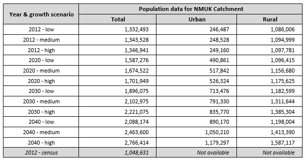
As of 2012, the total population in the catchment was assessed (2012 population census) at 1,085 million dispersed throughout the catchment with highest densities in and around the urban center of Musanze and along the Musanze - Rubavu national road. Catchment wide population data are given in the table below. The provisional 2012 census data per sector have been converted to population per catchment. The 2012 census result for the NMUK catchment stands at 1,048,631 population which is 21.30 % below the low growth scenario projection. Over the period 2002 - 2012 this equates to an annual difference of 1.95 % (overestimation of the projection data).
As regards the development of land resources, and as already indicated above, the bulk of the land is used for rainfed agriculture with a minor part dedicated to forest plantation and natural open land for dairy production (the latter in the Gishwati forest reserve area). Bench - and radical terraces are implemented throughout the catchment but the surface area thus protected from erosion, remains limited. Cheaper erosion protection works like trenches, contour plantations, etc. are widespread. Borders of lakes and water courses are protected by law from exploitation for agricultural use. Urban areas are limited in size and not very congested Reserved areas are the Volcano National Park, the Rugezi wetland and Bihinga Lake and remain in principle undisturbed.