Akanyaru Catchment (NAKN)
The starting point of the Akanyaru catchment is located in the south west of the catchment at high altitude on the eastern flanks of the Congo Nile water shed in the southern part of the Nyungwe forest reserve. While small, this area is fully protected and essentially void of human occupants. The remainder of the catchment consists of a series of tributaries with more (in the south west) or less (in the north east) steep gradients towards the Akanyaru River. This river forms the border with Burundi for most of its length until it reaches the Cyohoha Lake.
In the south of the catchment, the Akanyaru River is itself a mountain stream with a very steep gradient ranging from 5 to 15% with a high potential for sediment transport. Erosion is very prominent in the upper reaches of the catchment (most of Nyaruguru district). The Akanyaru mountain stream ultimately falls into the Akanyaru marshland which features a very low gradient (a few decimeters per kilometer) as the river turns north towards its confluence with Cyohoha Lake from where the river ceases to be 'transboundary'. From there the floodplain goes on until it reaches after some 100 kilometers its ultimate confluence with the lower Nyaborongo. It is worthwhile to mention that the very low gradient of the lower reach of the Akanyaru River is caused by the ridge of the Rusumo falls which brings about this same type of floodplain river flow not only in the Akanyaru but also in the Upper Akagera and Lower Nyabarongo Rivers.
With a clearly defined transboundary catchment area, no upstream inflow area and an outflow location, the Akanyaru catchment is properly demarcated. A subdivision of the catchment or a downstream extension would compromise the monitoring of the catchment outflow and thus one of the prerequisites for proper water management. A substantial part of the catchment area is located in Burundi which calls for transboundary water management procedures.
The surface areas of the different parts of the catchment are as follows :
- Land area of the NAKN catchment within Rwanda is 3,384 km² of which 116 km² is reserved area in Nyungwe forest;
- The Akanyaru marshland covers about 330 km² and is shared between Rwanda (210 km²) and Burundi (the remaining 120 km²).
- The Cyohoha South Lake covers about 64 km² of which 17.5 km² is located in Rwanda and the remainder in Burundi.
- The Cyohoha North lake has essentially dried up in early 2000 and the remaining open water area is about half a km² (0.56 km²)
- The total area of the NAKN catchment in Rwanda is 3,402 km²
- The transboundary domain of the catchment within Burundi is 1,926 km²
- The total catchment area of the Akanyaru catchment is consequently 5.328 km².
The catchment area is essentially covered by the following seven districts (Nyaruguru, Gisagara, Nyanza, Ruhango, Bugesera, Huye and Kamonyi). Some small parts of the catchment are located in the districts of Nyamagabe and Muhanga.
A further subdivision of the elongated level 1 catchment of 3,402 km² has been suggested as follows for the creation of three level 2 sub-catchments :
- Akanyaru hills (NAKN_1). This sub catchment comprises the upper section of the Akanyaru River where it is characteristic for an upland water course cutting through deep and narrow valleys with substantial erosion problems (area of 1,182 km² in Rwanda); the last tributary in this section is the Migina River. This part of the Akanyaru River receives a minority yet non negligible trans-boundary contribution from Burundi in the south.
- Akanyaru valley left bank (NAKN_2). The lower section of the Akanyaru which is a flat and wide marshland with several wide tributaries with substantial potential for agricultural development and peat production in the Akanyaru marshland. The Akanyaru marshland forms the boundary between Rwanda and Burundi (area of 1,560 km² in Rwanda) and the river receives a significant contribution from Burundi.
- Akanyaru Cyohoha (NAKN_3). The entire right bank catchment of the Akanyaru within Rwanda including the north and south Cyohoha lakes. Because of the fragile hydrological conditions, these lakes and the transition to marshland require special protection and monitoring measures. This sub-basin receives a substantial contribution from Burundi through the Cyohoha South Lake and its catchment. (area of 660 km² in Rwanda).
The principal water resources in the catchment are as follows (considering Rwandan resources exclusively) :
- the average annual rainfall is 1,225 mm/annum which equates to some 4,167 hm³/annum from the total land surface area 3,402 km².
- the combined average annual surface flow generated from the numerous small catchments in Rwanda stands at 25 m³/s or some 798 hm³/annum.
- the groundwater annual recharge / safe yield is about 531 hm³/annum. With a total storage of 5,103 hm³/annum the mean residence time of groundwater is about 10 years.
Land characteristics in the catchment are summarily presented as follows:
- the lithology of the catchment is largely dominated by granite and pegmatite layers with a shale deposit extending on either site of the lower Akanyaru River. This is completed with isolated smaller areas with volcanic material (basalt) or quartz layers throughout the catchment with slightly increased occurrence in the west. Lower valleys of tributaries of the Akanyaru River contain alluvial material of mineral origin while the Akanyaru valley itself and the Cyohoha North Lake present extensive peat deposits. Reasonably deep weathering of the dominant deposits (granite / shale) is offset by a low storage capacity and conductivity which gives low borehole yields. The possibilities for groundwater abstraction are somewhat better for the small quartz deposits.
- the soil classes are predominantly the nitisol - acrisol -alisol - lixisol' class with substantial areas of the ferralsol class especially in the south west and the east. This is completed with pockets of cambisol and mineral soils conditioned by flat topography (partly river valleys, partly plains). The Akanyaru river valley contains histosols. Infiltration rates of these soils are generally high except for the mineral sols on flat topography, rare spots of clay encountered in the center of the catchment and the urban domain of Huye.
- the land cover of the catchment is very largely dominated by rainfed agriculture and (irrigated) agricultural wetland. Natural wetland (>65% of natural vegetation) is found on the lower stretch of the Akanyaru river but this is likely due to excessively wet conditions. Significant coverage of reserved natural forest area is found in the west in Nyungwe forest and in the east. Small pockets of forest plantation are found throughout the catchment. Natural open lands are few. Open water is essentially found in Cyohoha South lake because the Cyohoha North Lake has been dried up in early 2000. The built-up areas are small and few mainly on the borders of the catchment related to the urban centers of Ruhango, Nyamata and Huye (Ngoma and Tumba).
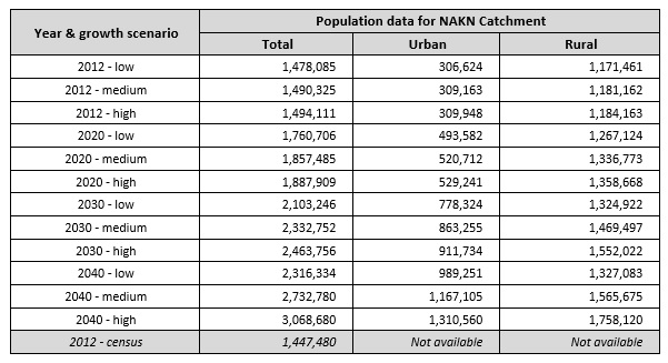
As of 2012, the total population in the catchment was assessed (2012 population census) at 1,447 million dispersed throughout the catchment with highest densities in and around the urban centers of Huye, Ruhango, Muhanga and Ruhuha. The urban center of Nyamata lacks behind in population density which is possibly related to the prevalence of relatively poor soils (Ferralsols). Catchment wide population data are given in the table below. The provisional 2012 census data per sector have been converted to population per catchment. The 2012 census result for the NAKN catchment stands at 1,447,480 population which is 2.07 % below the low growth scenario projection. Over the period 2002 - 2012 this equates to an annual difference of 2.05 ‰ which is a truly marginal overestimation of the projection data).
With respect to the development of land resources, and as already indicated above, the bulk of the land is used for rainfed agriculture, forest plantation and irrigated/ agricultural wetland. Dairy production is a complementary activity and free grazing is generally prohibited. Bench and radical terraces are implemented throughout the catchment but the surface area thus protected from erosion, remains limited. Cheaper erosion protection works like trenches, contour plantations, etc. are widespread. Borders of lakes and water courses are protected by law from exploitation for agricultural use. Urban areas are limited in size and not very crowded. Agriculture wetlands are limited along Akanyaru River, its tributaries and around Cyohoha north lake.