Lower Akagera Catchment (NAKL)
The lower Akagera catchment commences at the overflow of the Rusumo falls and belongs to the Nile basin. It is a downstream catchment that conveys the flow from the upper Akagera and Ruvubu rivers from South to North along the border of Rwanda with Tanzania. The lower Akagera is consequently a trans-boundary catchment over its entire length. Considering the breadth of the river, the need for shared water management activities at the local level is not very acute.
After a strong decent over the Rusumo falls for some 30 km, the Akagera river follows its meandering path through a fast expanse of floodplain, marshlands and lakes extending up to 20 km in Rwandan and Tanzanian territory until it runs after some 80 km into a much narrower channel (a few hundreds of meters) that runs for about 30 km north to the border town of Kagitumba and the confluence with the Muvumba River which marks the downstream limit of the lower Akagera catchment.
Apart from the numerous lakes which are without exception in open connection with the river the main tributaries are the Kamiramugezi and the Karangaza, both joining the Akagera on its last stretch in the north east.
With a clearly defined upstream inflow location, a transboundary catchment area and an outflow location, the lower Akagera catchment is properly demarcated. A subdivision of the catchment would compromise the monitoring of the catchment outflow and thus one of the prerequisites for proper water management.
The surface areas of the different parts of the catchment are as follows :
- Surface area of the catchment within Rwanda : 4,288 km²
- Reserved area in Akagera National park : 1,065 km²
- Lake area of the catchment within Rwanda : 239 km²
- Catchment area in Tanzania : 2,354 km² (across Akagera River)
- Total area of the NAKL catchment : 6,642 km²
- Upstream catchment area from Akagera River within Rwanda : 16,982 km²
- Upstream catchment area in Burundi and Tanzania (lake Rweru and Ruvubu river) : 13,714 km²
- Grand total of the Lower Akagera at Kagitumba : 37.338 km²
The catchment area is essentially covered by four districts (Nyagatare, Gatsibo, Kayonza and Kirehe). A smaller section of the catchment is located in the district of Ngoma.
A further subdivision of the elongated level 1 catchment of 4,288 km² has been examined but was finally rejected. The only logical subdivision would be to consider the Kamiramugezi and then the Karangaza tributaries as separate entities with the remainder being the lake domain in the Akagera Park. As neither one of the tributaries is monitored and the remaining area is essentially national park, it was decided to maintain the catchment as a single management unit. If ever there is a management need to implement a level 2 subdivision, monitoring stations can be installed and operated. The main features of the catchment area are as follows:
- The Akagera river with a normal river course over some 25 km feeding a very wide and flat swamp domain with lakes mostly located in the National Park over a length of 80 km to exit via a narrow valley of 30 km length.
- The Lake Nasho complex in the south with the three lakes of Nasho, Cyambwe and Mpanga) is being developed for major irrigation infrastructure.
- The Kamiramugezi is a non perennial water course and narrow sub catchment that runs in parallel to the Akagera over almost the entire length of the main catchment from South to North.
- The Karangaza is another non perennial water course fed from a narrow sub catchment that drains the north western part of the catchment.
The principal water resources in the catchment are as follows:
- The average annual rainfall is slightly below 850 mm/annum (835 mm) which equates to some 3,580 hm³/annum from the total land surface area of 4,288 km².
- The combined average annual surface flow generated from the two mentioned tributaries (Kamiramugezi and Karangaza) and a series of smaller catchments that fall into the Akagera stands at 29 m³/s or some 904 hm³/annum.
- The groundwater annual recharge / safe yield is about 536 hm³/annum. With a total groundwater storage of 4,824 hm³/annum the mean residence time is about 9 years.
The surface runoff of the catchments own resources and the excess flow from the river is stored in the lakes and the extremely wide Akagera floodplain. The main effect of this is a significant increase of evaporation losses to a total of 2,676 hm³/annum.
Land characteristics in the catchment are summarily presented as follows:
- The lithology of the catchment is dominated by the quartz rich schist and quartz layers in fault zones in the central part of the catchment extending all the way south providing the foundation for most of the Kamiramugezi sub catchment. The remainder of the area presents: outcrops of granite and pegmatite aquifer especially in the Karangaza subcatchment, some small areas in the south with volcanic and basalt material, extensive areas of peat in the Akagera floodplain, and alluvial material in the Kamiramugezi and Karangaza river valleys. The quartz rich schist and the quartzite have great potential for the exploration of groundwater resources but require proper investigation. The recharge of groundwater is low due to low rainfall and high evaporation. The granite basement aquifer in the north has relatively low storage in the weathering and saprolite layer. Exploration depends on the presence of fractured zones.
- The soil classes are the ferralsol class found throughout the catchment area with a profound dominance in the north west. The central and southern parts of the catchment present an alteration of cambisol and 'nitosol - acricol -alisol - lixisol' the already mentioned ferralsols and mineral soils conditioned by flat topography. Clay soils with low infiltration rate are found in the Kamiramugezi and Karangaza valley bottoms, and the Akagera river presents vast areas of histosols. Except for the clay soils and the mineral soils conditioned by flat topography, infiltration rates of these soils are generally high.
- The land cover of the catchment is largely dominated by natural open land, which is used for grazing when outside of the Akagera National Park. Rainfed agriculture, which is the dominant land use in other catchments, is limited to the western fringe of the catchment over the entire length from South to North. Some wetlands of the upper Kamiramugezi and Karangaza rivers are suitable for irrigated / agricultural wetland and some small pockets of land throughout the catchment are used for forest plantation. The remainder of the catchment is very small built up areas for emerging urban areas around Gatsibo, Kayonza and Kirehe, as well as open water and natural wetland.
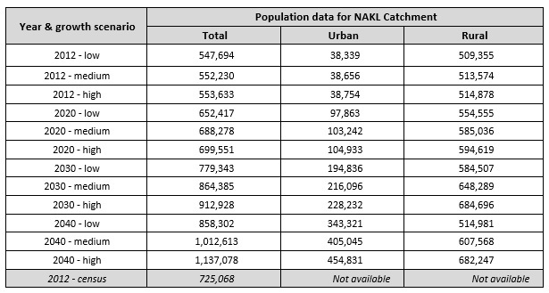
As of 2012, the total population in the catchment was assessed (2012 population census) at 725 thousand dispersed throughout the catchment with highest densities in and around the urban center of Nyagatare and Ngoma (Kibungo). Catchment wide population data are given in the table below. The provisional 2012 census data per sector have been converted to population per catchment. The 2012 census result for the NAKL catchment stands at 725,068 population which is 31 % above the high growth scenario projection. Over the period 2002 - 2012 this equates to an annual difference of 2.73 % (underestimation of the projection data). The area of the National Park has been reduced substantially in order to accommodate an influx of population from other areas.
As regards the development of land resources, and as already indicated above, the bulk of the land is natural open land for dairy production, rainfed agriculture, forest plantation and wetland development for irrigated agriculture. Most of the natural lakes are within the reserved area of the National Park but the Lake Nasho complex is exploited for fishing with good potential provided that the halieutic resource is adequately managed (protected from overexploitation and exploited with suitable gear).
Bench - and radical terraces are implemented throughout the catchment but the surface area thus protected from erosion, remains limited. Cheaper erosion protection works like trenches, contour plantations, etc. are widespread. Borders of lakes and water courses are protected by law from exploitation for agricultural use. Urban areas are limited in size and not very crowded. Agricultural wetlands are few.